Map Data
General Information
Map data is available in the SDE or through ESI. Objects like regions, constellations, solarsystems, planets, moons, and other celestial bodies have a position.
There are two kinds of position, each using their own coordinate system:
-
Relative to the center of the New Eden cluster. (Used by regions, constellations, solarsystems)
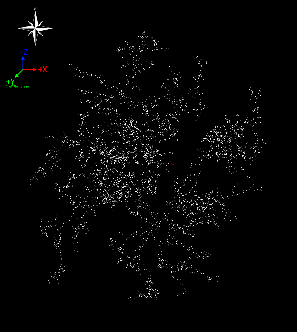
The center of the cluster lies near Zarzakh, labelled "Point of No Return" on the in-game map. (See the red dot on the cluster map below)
For systems in the New Eden Cluster both a 'geographic' position and a 'schematic' position ("position2D") is provided. The former is the actual position of the solarsystem, used for jump range calculations and the in-game 3D map. The latter is used for the in-game 2D map. -
Relative to the center of a solarsystem. (used by planets, moons, stars, as well as other positions within a solarsystem such as killmails)
The center of a solarsystem is it's star. The star objects themselves do not have an explicit position in the SDE or ESI, as their position is always[0.0, 0.0, 0.0]
Not every solarsystem has a star object; for abyssal deadspace systems with neither star nor planet, the origin is an arbitrary point.
These coordinate systems have the same scale (1.0 = 1 meter), but different directions.
Universe
All regions, constellations, and solarsystems share a single coordinate system.
The SDE contains map data in the map-prefixed files, such as mapRegions, mapConstellations, and mapSolarSystems.
ESI provides this data through endpoints under the /universe/ such as /universe/regions/.
For both SDE and ESI, data is provided for all kinds ('known space', 'wormhole space', 'abyssal space') of space. Different kinds of space can be identified by the ID ranges for the regionID, constellationID or solarSystemID.
Only the 'New Eden' solarsystems (SolarSystemID in the range 30,000,000 to 30,999,999) are included on the in-game map.
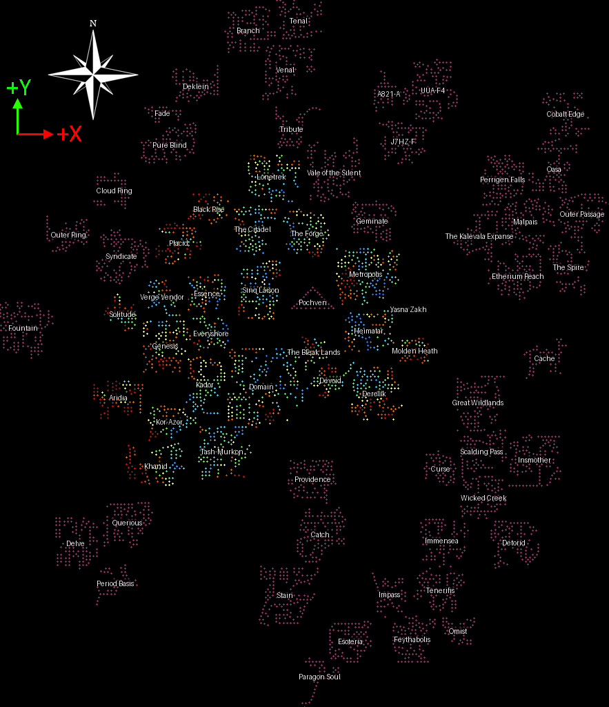
Map
When displayed by the in-game map & most community maps, the mapping convention is to look "top down" oriented with the region of 'Venal' at the top as a "Space North". In this orientation, the coordinates have the following directions:
+Xis East/Right,-Xis West/Left.+Yis Up,-Yis Down.+Zis North/Forward,-Zis South/Backward
Note
This forms a Left-Handed coordinate system. If you are using a 3D graphics or geometry library, it may expect either Left- or Right-Handed coordinates. Using incorrect handedness results in a 'mirrored' image which rotations alone cannot correct. You can convert handedness by negating a single axis. (e.g. [X, Y, -Z])
2D 'schematic' Map
The 2D 'schematic' positions follow the same conventions, with the position2D X coordinate pointing in the same direction as the 3D position X coordinate, and position2D Y coordinate pointing in the same direction as the 3D position Z coordinate.
Route calculation
See Route Calculation for details how to calculate a route in New Eden.
Jump drives
Unlike stargate connections, jump drives can reach any valid system within range in a single jump. Jump drives allow jumping to any low- and nullsec system, with the exclusion of Pochven and the Jove regions. Ships can also jump from high-sec space into low- or nullsec. Jump drive range is determined by the ship the player is piloting and their 'Jump Drive Calibration' skill.
A graph can be built by linking each solarsystem to every other solar system that may be jumped to. For a given system1 and system2 and their positions (x, y, z), the systems are in jump range if:
\(\sqrt{\left(x_1-x_2\right)^2+\left(y_1-y_2\right)^2+\left(z_1-z_2\right)^2}\le\ (Jump\ range\ in\ LY\ \ast\ {9\,460\,000\,000\,000\,000.0})\)
Caution
For the purposes of jump drive range calculation, a single lightyear is exactly 9,460,000,000,000,000.0 (9.46 × 10^15) meters, slightly less than the real world scientific definition of a lightyear.
Using the incorrect value may cause routes to include impossible jumps.
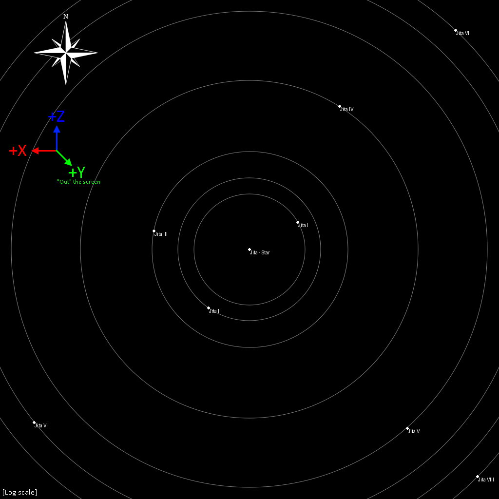
Solarsystem
Each individual solar system in the game has its own isolated coordinate system, with planets & other celestial objects having their positions given relative to the star.
When matching the 'Space North' orientation as used by the in-game map (see above), the coordinate system is as follows:
In this orientation, the coordinates have the following directions:
+Xis West/Left,-Xis East/Right.+Yis Up,-Yis Down.+Zis North/Forward,-Zis South/Backward.
Note
This is different to the Universe's coordinate system, and is Right-Handed.
Combining the coordinate systems
Both coordinate systems have the same scale but different axes. To get the position of a planet within the larger 'universe' coordinate system, it's position can be added to that of the parent star with the x coordinate negated: x = xsystem - xplanet y = ysystem + yplanet z = zsystem + zplanet
Note: Floating point precision
32-bit floating point numbers do not have enough precision to handle both the 'large' scale of the interstellar distances and the 'small' scale of interplanetary distances when combining the position of stars and the celestial bodies orbiting them as described above.
This problem can be mitigated by using 64-bit "double precision" floating point numbers.
In 3D rendering or other situations where 64-bit numbers are unavailable, "Floating Origin" techniques can also mitigate this problem.
Example: 3D map rendered as an image
To draw a map of the universe, the 3D coordinates need to be transformed into 2D positions on an image. The transformation required varies depending on the coordinate system used by the image.
This example uses the common "top-left origin" coordinate system widely used in images & 2D graphics. Here the (0,0) origin lies in the top-left corner of the image, the X axis points right and the Y axis points down.

These image axes map onto the axes of the universe data as follows:
- Ximg = Xeve
- Yimg = -Zeve
- The Yeve coordinate is discarded to flatten the map vertically.
After this, the coordinates must be moved and resized to fit within the image canvas. This can be done by calculating a bounding box, subtracting the position of the top-left corner of the bounding box from each coordinate, then dividing by width or height of the bounding box. This yields a position in the range 0 to 1, which can then be multiplied by the image width or height to get a final pixel position.
import json
from PIL import Image, ImageDraw # Using 'Pillow' for image drawing.

# Load data from SDE; `system_coordinates` as a list of `(x, y, z)` tuples
system_coordinates = []
with open("./mapSolarSystems.jsonl", encoding="utf8") as f:
    for line in f:
        system = json.loads(line)
        if int(system["_key"]) <= 30_999_999:    # "_key" is the solarSystemID; Load only the systems in the New Eden cluster
            system_coordinates.append((system["position"]["x"], system["position"]["y"], system["position"]["z"]))


# Image config
IMG_SIZE = 1024
STAR_RADIUS = 1

# Determine bounding-box
xMin, xMax, zMin, zMax = 0,0,0,0
for (x, y, z) in system_coordinates:
    xMin = min(xMin, x)
    xMax = max(xMax, x)
    zMin = min(zMin, z)
    zMax = max(zMax, z)

MAP_SIZE = max((xMax - xMin), (zMax - zMin))
ASPECT_RATIO = (xMax - xMin) / (zMax - zMin) # The cluster is not perfectly square, adjust image width to match aspect ratio to avoid the map becoming 'stretched' into a square

img = Image.new("RGBA", (int(IMG_SIZE * ASPECT_RATIO), IMG_SIZE), (0, 0, 0, 255))
draw = ImageDraw.Draw(img)

for (x, y, z) in system_coordinates:
    draw.circle(
        (
            # To convert the coordinates from 3D to pixel positions:
            # 1) Subtract the minimum value to set the lowest value to 0.0
            # 2) Divide by MAP_SIZE (the difference between max and minimum value) to set the highest value to 1.0
            #    This places all X coordinates in the range 0.0 - 1.0
            # 3) Multiply by IMAGE_SIZE, placing all X coordinates in the range 0.0 to IMG_SIZE, in pixels
            (x-xMin)/MAP_SIZE * IMG_SIZE,
            # Repeated for the Z coordinate, which is inverted as the map coordinate axis points in the opposite direction as the pixel coordinates.
            # Accordingly, the maximum ("least negative") value is subtracted instead
            (-(z-zMax))/MAP_SIZE * IMG_SIZE
        ),
        STAR_RADIUS,
        fill=(255, 255, 255, 255)
    )

img.show()
The 2D "schematic" positions can be used similarly, with the 3D Z coordinate replaced by the 2D Y coordinate:
- Ximg = Xeve
- Yimg = -Yeve
A solarsystem map uses different axes; The X-axis points in the opposite direction for celestial body coordinates, both the Xeve and Zeve are negated:
- Ximg = -Xeve
- Yimg = -Zeve
Tip
Use logarithmic scaling for maps of solarsystems, as the distances between objects span several orders of magnitude.